Preflight Planning
This section relates to preflight planning specific to seaplanes. Standard items for preflight planning related to all aircraft still apply.
Performance
Seaplane performance is determined by many of the same variables familiar to the landplane pilot, though the seaplane will be impacted by them to a greater degree. In addition, some of these variables, such as wind and density altitude are harder to calculate in an off-airport environment. The primary variables that cause performance issues with the seaplane relate to water drag on takeoff and landing. Water drag increases exponentially with ground speed. Anything that causes increased ground speed will significantly increase water drag and have a negative effect on the seaplane’s performance. The primary factors addressing water drag include:
- Weight and Balance
- Wind and Water Surface
- Density altitude
Each of these items will be addressed separately.
In addition to these factors, the seaplane is less forgiving of poor pilot technique. Pilot technique is a critical factor when margins are smaller, such as operating with heavy loads, high density altitude, or glassy water conditions.
Weight and Balance
Weight and balance (W&B) concepts are the same for seaplanes as for other aircraft. The seaplane must have the center of gravity within approved limits. There are also some W&B concerns specific to seaplanes.
- In addition to airborne concerns such as structural stress, seaplanes are impacted more significantly by weight increases because of water drag during takeoff.
- A center of gravity (C&G) too far aft can keep the aircraft from getting on the step.
- An unbalanced load will put more weight on one float and may cause unexpected water handling characteristics.
Wind and Water Surface
Like a landplane, the seaplane benefits from taking off and landing into the wind. The velocity of the wind increases the coefficient of lift without an increase in ground speed. As such, the increased headwind reduces the ground speed needed for the same amount of lift. So the seaplane pilot should take off and land into the wind in most cases. There are some exceptions to this rule when operating on rivers. Taking off or landing with a tailwind requires an increase in ground speed to overcome the tailwind. This increase in ground speed comes with a significant drag penalty due to the water drag increasing exponentially as speed increases. On takeoff the increased drag may make it difficult for the airplane to obtain takeoff speed. On landing, the drag on the floats may be significant and more than the pilot and/or controls are able to counteract. In such circumstances, the bows of the floats may submerge with disastrous results.
The water surface can play a major role in the drag imparted on the floats. Smooth water, or glassy water, causes more drag than water with some waves or ripples. Glassy water is caused by lack of wind or other turbulence. In addition to the missing benefit of a headwind, the smooth water has an increased surface tension on the floats causing more drag.
Density Altitude
Density altitude is pressure altitude corrected for non-standard temperatures. The higher the temperature, the less dense the air, which results in a higher density altitude. This has a great influence on seaplane performance. The primary reason is the that at higher density altitudes the aircraft needs increased ground speed for takeoff. With increased ground speed there is a significant increase in water drag during takeoff.
Density altitude can be calculated in a few steps. In many areas, a nearby AWOS/ASOS system is available to give the density altitude, but the steps below are how this is determined.
1) Determine the pressure altitude.
Pressure Altitude = (Standard Pressure – Current Pressure Setting) x 1,000 + Field Elevation
Example:
Current Pressure or Altimeter Setting: 30.10
Field Elevation: 1020 feet
Pressure Altitude = (29.92 – 30.10) x 1,000 + 1020 = 840
2) Calculate the Standard Temperature for the area
The standard temperature is 15 degrees Celsius at sea level. As the air naturally gets cooler with altitude, the standard temperature for a specific elevation must be determined. As the altitude rises, the standard temperature decreases by two degrees Celsius. The formula to calculate the standard temperature is below.
(standard temperature) – ((field elevation / 1,000) x 2
In our Example the field elevation is 1020 feet.
(15) – (1020 / 1,000) x 2 = 12.96 rounded to 13
Note: The variance from standard is often listed in aviation weather products.
3) Calculate Density Altitude
Density Altitude = Pressure Altitude + [120 x (Outside Air Temperature – Standard Temperature)]
Example Values:
Outside Air Temperature: 33 degrees Celsius (93 Fahrenheit)
840 + (120 x (33 – 13) = 3,240
So, in the example above, a field elevation of 1,020 feet at 33 degrees Celsius (93 Fahrenheit) would result in a density altitude of 3,240 feet. Such a difference will significantly impact the aircrafts performance.
For training, a high-density altitude environment can be simulated by practicing takeoffs without using full power. There should be a waterway for this practice as this will take much more real estate. In addition, this practice should be minimized as heat can build up in the engine.
Cross Country Planning
When operating a seaplane away from home, there are some additional considerations for a seaplane on straight floats. At a minimum, the pilot should:
- Ensure that all water landings are completed prior to dusk. Do not get caught needing to land after dark with straight floats. If a night landing is required, a lighted runway with a tower should be considered as such an airport can provide additional assistance.
- Plan for fuel. Not many areas in the country have 100LL available at the water. In some cases, the pilot may be able to call and have it delivered from a local airport.
- Calculate performance. Performance will be degraded with floats. The trip time will likely be longer than with a landplane. Ensure proper information for the float equipped airplane is used.
- Review landing areas. As the landing will likely be in an off-airport environment, landing areas should be identified prior to departure. This is especially true of landing areas not frequented by seaplanes.
For amphibian aircraft, the primary issue is storage and ground movement of the aircraft if there is an extended stay at a location. Call ahead or bring an appropriate tow bar. If the plane is to be secured in a hangar, ensure that the ramp personnel are aware of the dimensions of the seaplane. An amphibian is much taller than most other general aviation aircraft. Also, consider fueling the aircraft personally. Ramp personnel that are likely not familiar with seaplanes may use the fuel nozzle as an extra hand hold, which may damage the fuel inlet.
Landing Areas
When flying a seaplane, the pilot needs to understand where they can land. Amphibian operations on land are no different than land-based aircraft. However, water landings are another story. Below are a few items with relation to water landings for all seaplanes.
Emergency: In an emergency, any feasible body of water can be used. The landing should be reported to authorities as applicable.
Feasibility: Ensure that the body of water is free of obstacles and is an appropriate length and depth for the aircraft being flown.
Approval: To avoid problems, plan ahead and know if the body of water where the anticipated landing is planned is approved for seaplane operations. Unless under federal jurisdiction, navigable bodies of water are under the jurisdiction of the state, or in a few cases, privately owned. Aircraft have as much right to operate on these bodies of water as other vessels unless the body of water is specifically restricted. Check with federal, state, or local officials in advance of operating on unfamiliar waters. Below are several resources for determining if seaplane landings are allowed on a specific waterway.
- Water Flying Directory: This listing from the Seaplane Pilots Association includes a lot of information related to authority of a waterway.
- Chart Supplement: Identifies seaplane bases
- Wilderness Area: U.S. Forest Service (National Forests)
- National Park: U.S. National Park Service
- Corps of Engineers managed water ways: U.S. Army Corps of Engineers
- Indian Reservations: Bureau of Indian Affairs
- State Parks: State governments
- Local agencies or private entities as identified via available resources.
Many times, there are different regulations concerning private and commercial operations. For example, personal seaplane landings can be made on U.S. Army of Corps of Engineers’ managed waterways, while on many of these same waterways, written permission from the agency is required for commercial operations.
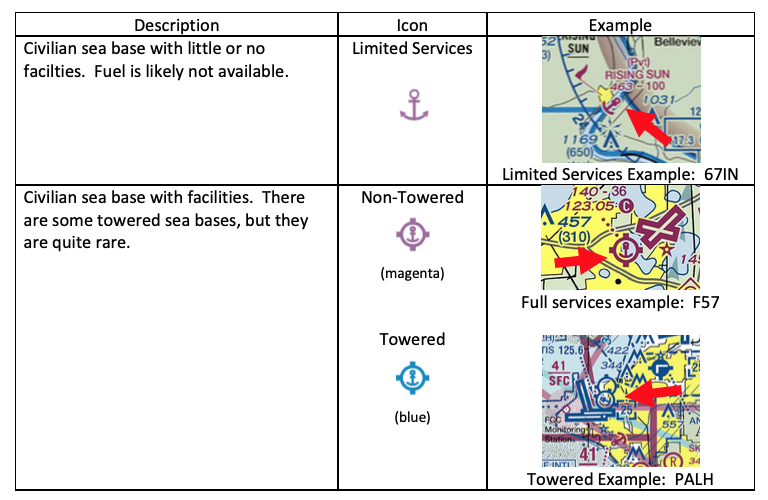
A designated sea base will be identified on a chart with an anchor symbol. The basic anchor has minimal services, if any. The anchor with the circle and tick marks has services, such as fuel. The top of the anchor, space permitting, is located at the primary base. Examples are below. There are designations for military sea bases, but there are no such active bases in the U.S.
 Some sea bases may have an anchor symbol visible from the air. This anchor may be painted on a roof or other visible area. The size of the anchor is about 13ft by 8ft.
Pilot Currency
Like all other flying, the pilot must be appropriately rated in the aircraft, have a current medical, have a current flight review, and have recent flight experience to carry passengers.
Recently of Flight Experience
To operate as pilot in command to carry passengers, the pilot must have conducted three takeoffs and landings in the same category and class aircraft (and type rating if required), within the preceding 90 days. As such, a single engine seaplane pilot must conduct three takeoffs and landings on the water to act as pilot in command while carrying passengers. If flying an amphibian and landings on a runway are planned, the pilot would need to be current in single engine land by conducting at least three takeoffs and landings on a runway within the last 90 days. Basically, an amphibian on land is the same a non-amphibian landplane. If planning to takeoff and land on a runway and waterway in an amphibian with passengers, the pilot needs to be current in both runway and waterway takeoffs and landings.
It is very unlikely that a new seaplane pilot will find a seaplane that requires a type rating, but there are a few large transport seaplanes primarily used in firefighting that do require type ratings.
Flight Review
To be current for solo flight, or to act as pilot in command, the pilot must have a current flight review. The flight review can be conducted in any category or class of aircraft. If conducting a flight review in a landplane, the pilot will have renewed their seaplane category as well, and vice versa.
Medical
The medical requirements are no different than the landplane requirements.
DEFINITIONS:
Center of Gravity (CG): The point at which an airplane would balance if suspended. Its distance from the reference datum is determined by dividing the total moment by the total weight of the airplane. It is the mass center of the aircraft, or the theoretical point at which the entire weight of the aircraft is assumed to be concentrated.
Density Altitude: Density altitude is pressure altitude corrected for non-standard temperature.
Seaplane Base: A designated area of water used or intended to be used for the landing and takeoff of seaplanes and shore side access. It also may include water taxi channels, anchoring locations, ramp service, and possibly on-shore facilities for pilots, passengers and aircraft needs.
Seaplane Landing Area: Any water area designated for the landing of seaplanes.
QUESTIONS:
What are two primary concerns when determining whether to use a water landing area? Two primary concerns when identifying a landing area are feasibility of the area and authority to land there. Ensure the water has adequate length and depth and is free of obstacles. Unless it’s an emergency landing, the pilot should ensure they have authority to land on that body of water.
How is a seaplane base identified on a chart? A sea base is identified on a chart with an anchor symbol. If fuel is available, the anchor is inside a circle.
How does a pilot know if they can legally land on a body of water? First, the pilot must determine who controls the body of water. A primary source is the Seaplane Pilots Association’s Water Landing Directory. Seaplane bases/facilities are located in the Chart Supplement (f/k/a Airport Facilities Directory). The National Park Service oversees waterways in national parks. The U.S. Forest services does the same for wilderness areas and national forests. The Army Corps of Engineers is responsible for overseeing seaplane activity on waterways they manage. In addition, the pilot may need to contact local or state offices.
How does a pilot maintain currency to carry passengers in a seaplane? A pilot must make three takeoffs and three landings in a seaplane. Currency must be in the same category (Airplane) and Class (Seaplane) and type if a type rating is required.
A pilot has two takeoffs and landings in a landplane, and one takeoff and landing in a seaplane within the last 90 days, is the pilot current? No, the pilot must have three takeoffs and landings in the same category and class. In this example, it is the same category (airplane) but different class (sea and land). As such, the pilot has not completed the required takeoffs and landings for either class.
A pilot is flying an amphibian, but all of the flights have been from the water for the last 90 days, is the pilot legal to take passengers from a land runway? No, the pilot must be current in land operations, so the pilot must make three takeoffs and three landings in the land configuration on a runway. The water operations do not count for land-based currency.